Skip to content

Property Owner Search - Find Who Owns Any Property by Address

Search property ownership records by address and access homeowner information
  • 160M+ Parcels
  • 3,143 Counties
  • 248M+ Loan Records
  • 300M+ Building Permits
  • 100M+ Homeowners
  • 26M+ Distressed Properties
  • As Seen On:
Good amount of details on the website for verifying any property
and excellent customer case service over phone. - Manish
PropertyChecker helped me with my Mother's estate.
I was able to get the information I needed from the website. - Katharine
Fast answers to my questions regarding a 40 year old deed.
- Ron
I liked the report that your website provided, that was what I was searching for;
it helped me to make a decision whether I should invest a property or not. - Youmei
Property Checker provides a great deal of information on a specific property.
It is very fast and easy to use - you'll have results in 1-2 minutes. - Joe
The information I rec'd was solid. The customer experience was great and when I contacted Support they were very attentive.
If you need information on properties, this is a great option. - Sarah
Accurate information... I was able to find accurate information about properties
that I was interested in purchasing. Very easy to use. - Antoinette G.
The information provided to me regarding my house deed, purchase history, school ratings etc.
was very comprehensive and informative. - Vincent P.
The report was so easy to create and it provided a great deal of useful information.
I really appreciated the availability. - Andrew M.

Find Property Owner by Address

In the past, finding a property owner often meant visiting a local town hall or registry of deeds to request a copy of the latest deed. With PropertyChecker, you can find the current property owner instantly from your computer. Simply enter a property address, parcel ID, owner's name, phone number, or email to quickly look up homeowner records and access property ownership information.

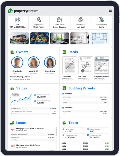
PropertyChecker makes it easy to determine who owns a property and whether it is owner-occupied. You can also see if the property is owned by an individual or a business entity.

A PropertyChecker ownership search may reveal:

  • Owner's Name
  • Phone Number
  • Mailing Address
  • Email (when available)
  • Owner Type (Individual or Corporate)
  • And More

Our databases also help identify the individuals behind entities that commonly hold property ownership, including:

  • Trusts
  • LLCs
  • Corporations
  • Other Registered Entities

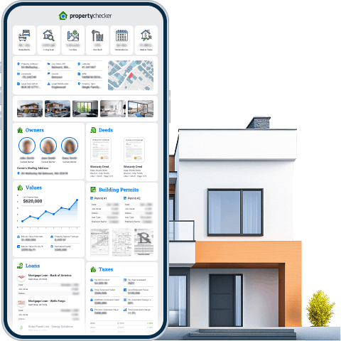
In addition to ownership details, PropertyChecker reports may include property characteristics (beds, baths, square footage), neighborhood insights, property taxes, estimated values, loan records, purchase history, building permits, foreclosures, liens, and more.

Access Property Ownership Records

Property ownership records are public documents that identify the legal owner of a property. When real estate is bought or transferred, the transaction is recorded with the local county recorder, registry of deeds, or municipal office. These recorded documents create an official history of property ownership.

A property owner lookup may include:

  • Current homeowner name
  • Ownership history
  • Recorded sale dates
  • Deed information
  • Assessed value
  • Parcel details
  • Transfer Document Numbers
  • And More!

These records help verify who owns a property and document how ownership has changed over time. PropertyChecker compiles publicly available property ownership records from multiple sources and presents them in a single, easy-to-read report. By searching an address or parcel ID, users can quickly uncover ownership details and related property information without needing to visit multiple government offices.

Our Property Reports Include (When Available):

  • Property Owner(s)
  • Purchase History
  • Loan Records
  • Deed Records
  • Property Details
  • Neighborhood Info
  • Tax Records
  • Property Values
  • Building Permits
  • Foreclosures
  • Lien Records
  • Zoning Info
  • Residents
  • Flood Risks
  • Noise Levels
  • And More!

PropertyChecker.com makes it easy to access detailed property records through a single search. Rather than spending time checking multiple county offices or public databases, our platform compiles key information, such as ownership history, liens, permits, property characteristics, and valuation data, into one organized report. Whether you're a homebuyer, investor, or property owner, PropertyChecker provides the insights you need to make informed decisions with fast, convenient access to reliable property data.

Frequently Asked Questions

How do I find out who owns a property?

You can search public property ownership records by entering the property address into a property owner lookup tool. Ownership data is recorded through county deed filings and tax records.

Can I find the owner of a property by address?

Yes. Property ownership records are searchable by address. A property owner search allows you to identify the recorded homeowner.

Are property ownership records public?

Yes. Property ownership records are public documents recorded at the county level.

How accurate is a property owner lookup?

Property owner searches pull from publicly recorded deed and tax data. Accuracy depends on the most recent recorded filings.

Can I see previous property owners?

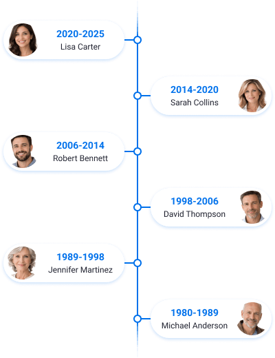
Yes. Ownership history may include prior owners, recorded transfers, and transaction dates.

Is it legal to search property ownership records?

Yes. Property ownership records are public information.

Can property ownership records be sealed or private?

While most are public, some records may be sealed or restricted for specific reasons, such as national security or safety for certain public officials.

Can I find a property owner's phone number or email?

Yes, using skip tracing, you can find a property owner’s phone number or email address when available.

What if the property is owned by an LLC or trust?

If a property is owned by an LLC or a trust, you can find the real owner behind the entity or trust using PropertyChecker.

How do I find the owner of a property if the records haven't been updated?

You can visit the County Recorder of Deeds in person to search for the most recent unrecorded or pending filings.

Support You Can Count On

Our team is available 24/7 whenever you need us.

Satisfaction Rate
99%
Avg. Response Time
~ 1 min
Chat Availability
24/7

Run Unlimited Property Ownership Lookups for Only $1.95!

Identify the individuals or entities behind a property, including trusts, LLCs, corporations, and other ownership structures. Access ownership details quickly and gain better insight into who truly owns a property.

Property Report for 123 Main St, Anytown, MA 02110

5br / 5ba Beds/Baths
3,450 sqft Living Area
0.45 acres Lot Size
1970 Year Built
4yr 8mo Ownership Length
$2,645,000 Market Value

Quick Facts

Foreclosure:
No
Pre-Foreclosure:
No
Free & Clear:
Yes
Tax Default:
No
Failed Listing:
No
Out-of-State Owners:
No
Probate:
No
Pre-Probate:
No
Divorce:
No

Summary

Monitor Property
Property Address:
123 Main St
City, State, ZIP:
Anytown, MA 02110
Latitude:
42.3601
Longitude:
-71.0589
County:
Barnstable
APN:
427-00-00-039
Legal Description:
165 SUBDIVISIONNAME JAMES ISLAND LOT 1
Legal Subdivision:
Englewood
Property Type:
Single Family Residence
Owner Status:
Owner Occupied
Owner Type:
Individual
Trust Description:
Not a Trust
Company Flag:
No
Property Use:
Residential
Stories:
2
Structure Style:
Contemporary

Owners

Owner's Name(s)

Owner's Mailing Address

Ownership Timeline

2020
Transaction Type:
Warranty Deed
Transaction Date:
05/05/2020
Purchase Price:
$1,800,000
2006
Transaction Type:
Quit Claim Deed
Transaction Date:
11/04/2006
1995
Transaction Type:
Warranty Deed
Transaction Date:
03/10/1995
Purchase Price:
$750,000
1970
Transaction Type:
Quit Claim Deed
Transaction Date:
04/22/1970

Deeds

Grantee’s Name(s):
John Smith
Deed Owner Address:
123 Main St, Anytown, MA 02110
Ownership Category:
Individual
Owner Occupied:
Yes
Grantor’s Name(s):
James Smith
Transaction Amount:
$500,000
Transaction Mortgage Amount:
$300,000
Transaction Type:
Transfer
Document:
2342-234
Title Company:
North American Title
Transaction Date:
04-04-2023
Document Type:
Quit Claim Deed
Property Type:
Commercial
Property Sub-Type:
Industrial
County:
Barnstable
Transfer Doc #:
2342342
Transfer Transaction #:
23424
Sale Document Book #:
234
Last Document #:
234

Parcel & Legal

Raw:
CHSR M:0224 L:0008
Formatted:
CHSR M:0224 L:0008
Year Added:
2007
Alternate:
285-090-10343
Map Book:
224
Map Page:
0008
Year Change:
2001
Account Number:
9417
Description:
LOT:8 DIST:58 CITY/MUNI/TWP:CHESHIRE
Subdivision:
WINDWOOD I & II
Lot Number:
199C

Building Permits

Building Permit #1

Effective Date:
02/16/2022
Job Value:
$492,000
Status:
Final
Type:
Bldg-new
Sub Type:
1 or 2 family dwelling
Business Name:
Otto Construction
Home Owner:
Jame M Smith
Fees:
$220
Permit Number:
21010-20000-05003
Description:
New 65'-2 x 47'-10 two story single family dwelling with attached garage; equipped with nfpa 13-d fire sprinklers throughout

Building Permit #2

Effective Date:
06/21/2020
Job Value:
$1,600
Status:
Final
Type:
Fire sprinkler
Sub Type:
1 or 2 family dwelling
Business Name:
Flame Master Sprinkler Company INC
Home Owner:
Jame M Smith
Fees:
$85
Permit Number:
22043-20000-02396
Description:
Nfpa 13d fire sprinkler system. 1 domestic water usage

Building Permit #3

Effective Date:
12/24/2014
Job Value:
$3,400
Status:
Final
Type:
Electrical
Sub Type:
1 or 2 family dwelling
Business Name:
Connect TO Electric INC
Home Owner:
Dana Jefferson
Fees:
$105
Permit Number:
21141-90000-27807
Description:
Install 100amp 240v temporary power pole

Building Permit #4

Effective Date:
10/08/2011
Job Value:
$75,000
Status:
Final
Type:
Swimming-pool/spa
Sub Type:
1 or 2 family dwelling
Business Name:
Berger Pool Plumbing INC; Peter Gillette; Walter Scott John
Home Owner:
Dana Jefferson
Fees:
$150
Permit Number:
15047-30000-00584
Description:
New pool and spa per standard plan 254

Values

Market Value

Market Value Estimate:
$2,645,000
Property Square Footage:
3,450 SF
Market Value Per Sq Ft:
$766/Sq Ft
Estimated Equity:
$1,900,000
Home Equity Change Since Purchased:
55%
Rent Estimate:
$3,250
Last Sale Date:
05/05/2020
Last Sale Amount:
$1,800,000

Comparables

Comparable Properties:
5
Avg. Sale Price:
$2,650,000
# Address Property Type Sold Date Sold Amount
1 67 Main St Single Family Residenial 04/23/2025 $2,840,000
2 190 Summer St Single Family Residenial 06/03/2025 $2,430,000
3 298 Congress St Single Family Residenial 06/30/2025 $1,900,000
4 23 Milk St Single Family Residenial 07/24/2025 $2,234,000
5 350 Grossman Rd Single Family Residenial 08/25/2025 $2,523,500

Loans

Current Loans

Loan #1

Transaction Mortgage Amount:
$1,200,000
Mortgage Date:
05/05/2020
Lender Type:
Bank
Loan Type:
Conventional
Lender:
Bank of America
Lender Code:
98765
Interest Rate:
7%
Loan Length:
30 Years

Loan #2

Transaction Mortgage Amount:
$150,000
Mortgage Date:
04/20/2022
Lender Type:
Bank
Loan Type:
Home Line of Credit
Lender:
Washington Mutual FSB
Lender Code:
98765

Previous Loans

Loan #1

Transaction Mortgage Amount:
$862,000
Mortgage Date:
10/16/2006
Lender Type:
Bank
Loan Type:
Adjustable Rate Mortgage
Lender:
People Bank & Trust
Lender Code:
3659

Loan #2

Current Transaction Mortgage Amount:
$635,000
Mortgage Date:
11/07/1995
Lender Type:
Bank
Loan Type:
Conventional
Lender:
JPMorgan Chase Bank NA
Lender Code:
564434

Taxes

Tax Bill Amount:
$31,320
Tax Year Assessed:
2025
Total Assessed Value:
$1,950,000
Land Assessed Value:
$1,100,000
Additions Assessed Value:
$850,000
Tax Assessed Change %:
80%
Previous Assessed Value:
$1,923,000
Total Assessed Change:
+1.5%
Last Assessor Tax Roll Update:
2025
Assessor Last Updated:
07-2025
Property Category:
Residential
Zoned Code Local:
R72
Property Use Standardized:
385
Property Use Municode:
R3598
Year Built:
1970
Tax Exemption:
No
Tax Delinquent:
No

Tax History

Year Property Taxes Change Tax Assessment Change
2024 $31,320 4.88% $1,950,000 2.00%
2023 $28,232 11.80% $1,525,000 4.23%
2022 $22,353 2.84% $1,225,000 1.04%
2021 $21,288 5.05% $1,121,000 2.00%
2020 $8,178 2.16% $764,787 2.00%
2019 $7,189 0.00% $661,557 2.00%
2018 $7,132 3.60% $658,390 2.00%
2017 $6,058 1.38% $555,285 1.52%
2016 $6,231 0.73% $552,954 2.00%
2015 $6,045 1.16% $549,959 0.45%
2014 $6,070 0.00% $549,283 2.00%
2013 $6,070 - $546,357 -

Images

Liens

Involuntary Liens

Involuntary Lien #1

Attorney Company Name:
WATER DEPARTMENT
Attorney Phone Number:
9783742370
Book Number:
39367
Document Number:
530
Document Type:
City Lien
Document Type Code:
BQ
Filing Date:
2020-12-23
Judgment Amount:
$2,439
Page Number:
351
Tax Period End Date:
2021-12-31
Lien Amount:
$2,550

Involuntary Lien #2

Document Number:
202512050280
Document Type:
Utility Lien
Document Type Code:
UT
Filing Date:
December 04, 2025
Lien Amount:
$124

Foreclosure / Pre-Foreclosure

Foreclosure

Not a forclosure

Pre-Foreclosure

123 Main St, Anytown, MA 02110

Record Type:
Lis Pendens
Property Address:
123 Main St
Property City:
Anytown
Property State:
MA
Property ZIP:
02110
Original Loan Recording Date:
05/05/2020
Original Loan Instrument Number:
--
Original Loan Book Page:
--
Borrower Name Owner:
John Smith
Original Loan Number:
21550
Original Loan Amount:
$750,000
Original Loan Interest Rate:
3.40%
Loan Maturity Date:
12/10/2025
Lender Name Full Standardized:
Benefincial Mortgage
Servicer Name:
Bank of America
Trustee Name:
Bierman, Howard
Foreclosure Instrument Date:
12/02/2025
Foreclosure Recording Date:
12/02/2025
Foreclosure Instrument Number:
21550
Foreclosure Book Page:
21550
Case Number:
21550
Trustee Reference Number:
B234BW3A
Payment:
$560,234
Default Amount:
$560,234
Penalty Interest:
3.40%
Loan Balance:
$560,234

Listing History

Listing Description

Charming Multi-Level Home in Sought-After Forest Park. Welcome to this beautifully maintained 5-bed, 5-bath home nestled on a quiet side street. Offering 3,450 sqft of thoughtfully designed living space, this home combines comfort, style, and convenience. Step inside to find hardwood floors and an open floor plan perfect for both everyday living and entertaining.

Listing Timeline

2025-04-21
Listed for Sale
$2,130,000
2025-05-13
Price Change
$2,100,000
2025-06-02
Sale Pending
$2,100,000
2025-07-12
Sold
$2,080,000

Price History

2025-07-12

Date:
2025-07-12
Price Change Rate:
-
Event:
Sold
Price:
$2,080,000

2025-06-02

Date:
2025-06-02
Price Change Rate:
-
Event:
Sale Pending
Price:
$2,100,000

2025-05-13

Date:
2025-05-13
Price Change Rate:
-4.5%
Event:
Price Change
Price:
$2,100,000

2025-04-21

Date:
2025-04-21
Price Change Rate:
-
Event:
Listed for Sale
Price:
$2,130,000

Property Details

5 Bedrooms
5 Bathrooms
3,450 Sq Ft Living Area
0.45 Acres Lot Size
1970 Year Built
2 Unit Count
3 Stories
Yes Basement
Yes Garage
No Parking
No Fireplace
Yes Pool
No Deck
Yes Patio
Yes Balcony
No Shed
No Accessibility
Concrete Foundation
Split Level Structure Style
Frame Construction
Asphalt Roof Material
Gable Roof Construction
Central Heating
Central Cooling

Home Owners Association

HOA Type:
HOA
HOA Amount:
$400
HOA Frequency:
Monthly

Rooms

Bath Count:
N/A
Bath Partial Count:
N/A
Bedrooms Count:
N/A
Rooms Count:
N/A
Stories Count:
N/A
Units Count:
N/A
Bonus Room:
N/A
Breakfast Nook:
N/A
Cellar Room:
N/A
Wine Cellar Room:
N/A
Exercise Room:
N/A
Family Room:
N/A
Game Room:
N/A
Great Room:
N/A
Hobby Room:
N/A
Laundry Room:
N/A
Media Room:
N/A
Mud Room:
N/A
Office Room:
N/A
Safe Room:
N/A
Sitting Room:
N/A
Storm Room:
N/A
Study Room:
N/A
Sunroom:
N/A
Utility Room:
N/A

Area

Building:
Beneficiary / Creditor - When Doc Type Bd, This Buyer Id Code Identifies The Person Designated To Acquire Title Upon Death Of Grantor.
Building Definition Code:
Beneficiary / Creditor - When Doc Type Bd, This Buyer Id Code Identifies The Person Designated To Acquire Title Upon Death Of Grantor.
Gross:
Beneficiary / Creditor - When Doc Type Bd, This Buyer Id Code Identifies The Person Designated To Acquire Title Upon Death Of Grantor.
1st Floor:
Beneficiary / Creditor - When Doc Type Bd, This Buyer Id Code Identifies The Person Designated To Acquire Title Upon Death Of Grantor.
2nd Floor:
Beneficiary / Creditor - When Doc Type Bd, This Buyer Id Code Identifies The Person Designated To Acquire Title Upon Death Of Grantor.
Upper Floors:
Beneficiary / Creditor - When Doc Type Bd, This Buyer Id Code Identifies The Person Designated To Acquire Title Upon Death Of Grantor.
Lot Acres:
Beneficiary / Creditor - When Doc Type Bd, This Buyer Id Code Identifies The Person Designated To Acquire Title Upon Death Of Grantor.
Lot SF:
Beneficiary / Creditor - When Doc Type Bd, This Buyer Id Code Identifies The Person Designated To Acquire Title Upon Death Of Grantor.
Lot Depth:
Beneficiary / Creditor - When Doc Type Bd, This Buyer Id Code Identifies The Person Designated To Acquire Title Upon Death Of Grantor.
Lot Width:
Beneficiary / Creditor - When Doc Type Bd, This Buyer Id Code Identifies The Person Designated To Acquire Title Upon Death Of Grantor.
Rooms Attic:
Beneficiary / Creditor - When Doc Type Bd, This Buyer Id Code Identifies The Person Designated To Acquire Title Upon Death Of Grantor.
Rooms Basement:
Beneficiary / Creditor - When Doc Type Bd, This Buyer Id Code Identifies The Person Designated To Acquire Title Upon Death Of Grantor.
Rooms Basement Finished:
Beneficiary / Creditor - When Doc Type Bd, This Buyer Id Code Identifies The Person Designated To Acquire Title Upon Death Of Grantor.
Patio:
Beneficiary / Creditor - When Doc Type Bd, This Buyer Id Code Identifies The Person Designated To Acquire Title Upon Death Of Grantor.
Deck:
Beneficiary / Creditor - When Doc Type Bd, This Buyer Id Code Identifies The Person Designated To Acquire Title Upon Death Of Grantor.
Balcony:
Beneficiary / Creditor - When Doc Type Bd, This Buyer Id Code Identifies The Person Designated To Acquire Title Upon Death Of Grantor.

Parking

Garage:
N/A
Garage Area:
N/A
Carport:
N/A
RV Parking Flag:
N/A
Space Count:
N/A
Driveway Area:
N/A

Construction Details

Roof Material:
N/A
Roof Construction:
N/A
Structure Style:
N/A
Exterior Code:
N/A
Foundation:
N/A
Construction:
N/A
Interior Structure:
N/A
Plumbing Fixtures Count:
N/A
Safety Fire Sprinklers Flag:
N/A

Property Features

Fireplace:
N/A
Fireplace Count:
N/A
Pool:
N/A
Pool Area:
N/A
Security Alarm Flag:
N/A
Accessibility Elevator Flag:
N/A
Accessibility Handicap Flag:
N/A
Escalator Flag:
N/A
Central Vacuum Flag:
N/A
Content Intercom Flag:
N/A
Content Sound System Flag:
N/A
Wet Bar Flag:
N/A
Content Storm Shutter Flag:
N/A
Content Overhead Door Flag:
N/A
Porch Code:
N/A
Porch Area:
N/A
Deck Flag:
N/A
Feature Balcony Flag:
N/A
Breezeway Flag:
N/A
Topography Code:
N/A
Fence Area:
N/A
Courtyard Flag:
N/A
Arbor Pergola Flag:
N/A
Golf Course Green Flag:
N/A
Tennis Court Flag:
N/A
Sports Court Flag:
N/A
Arena Flag:
N/A
Water Feature Flag:
N/A
Pond Flag:
N/A
Boat Lift Flag:
N/A
Buildings Count:
N/A
Bath House Flag:
N/A
Boat Access Flag:
N/A
Boat House Flag:
N/A
Cabin Area:
N/A
Cabin Flag:
N/A
Canopy Area:
N/A
Canopy Flag:
N/A
Gazebo Area:
N/A
Gazebo Flag:
N/A
Grainery Area:
N/A
Grainery Flag:
N/A
Green House Area:
N/A
Green House Flag:
N/A
Guest House Flag:
N/A
Kennel Flag:
N/A
Milk House Flag:
N/A
Outdoor Kitchen Fireplace Flag:
N/A
Pool House Flag:
N/A
Poultry House Flag:
N/A
Quonset Flag:
N/A
Shed Code:
N/A
Silo Flag:
N/A
Stable Flag:
N/A
Storage Building Flag:
N/A
Pole Structure Flag:
N/A
Publication Date:
N/A
Parcel Shell Record:
N/A

Utilities / Green Energy Details

HVAC Cooling Detail:
N/A
HVAC Heating Detail:
N/A
HVAC Heating Fuel:
N/A
Utilities Sewage Usage:
N/A
Utilities Water Source:
N/A
Utilities Mobile Home Hookup Flag:
N/A

Zoning Data

Zone Legend
  • BWLD - Braintree Something
  • C - Commercial
  • GB - General Business
  • HB - Highway Business
  • OS - Open Space
  • RES-A - Residence A
  • RES-B - Residence B
  • RES-C - Residence C
  • TD - Transition District
  • VC - Village Center
Zone Name:
Zone Code:
Zone Type:
Zone Sub Type:
Zone Guide:
As of Right:
Special Uses:
Prohibited:

Assorted:

Adu Permitted Municipal:
Adu Permitted State Override:

Far Control:

Maximum Floor Area Ratio:

Lot Control:

MIN Lot Area Sq Ft:
MIN Lot Depth Lot:
MIN Lot Area Sq Ft Lot:

Lot Control:

MAX Density DU Per Acre:

Flood Risk

  • Zone A – High-risk flood zone
  • Zone B – Moderate-risk flood zone
  • Zone D – Undetermined risk
  • Zone V – High-risk coastal flood zone
  • Zone AH – High-risk flood areas with shallow flooding
  • Zone AO – High-risk flood areas with sheet-flow flooding
  • Zone A99 – High-risk flood area
  • Zone V – High-risk coastal flood zone
  • Zone VE – High-risk coastal flood zone
  • Zone C – Minimal-risk areas
Map Info
Flood Zone:
Special Flood Hazard Area:
Zone Subtype:
Area of Minimal Flood Hazard Show Flood Risk Data
D Film:
Effective Date:
Elevation:

Wet Lands

Legend

Wetlands

  • Estuarine and Marine Deepwater
  • Estuarine and Marine Wetland
  • Freshwater Emergent Wetland
  • Freshwater Forested / Shrub Wetland
  • Freshwater Pond
  • Lake
  • Other
  • Riverine

Riparian

  • Forested / Shrub
  • Herbaceous

Noise Score

Soundscore™:
65
Busy
Traffic:
Busy
Airports:
Busy
Local Sources:
Active

Neighborhood

Area Information

Boston, Massachusetts, in 2026, stands as an enticing prospect for real estate investors, thanks to its strategic location within the Sunshine State. Situated in Palm Beach County, it enjoys close proximity to major cities like West Palm Beach and Fort Lauderdale. This prime location makes Palm Beach Gardens an ideal choice for those looking to invest in the flourishing Florida real estate market while enjoying the convenience of easy access to nearby urban centers. Palm Beach Gardens has experienced steady population growth in recent years, further solidifying its appeal as a promising investment destination. The increasing number of residents reflects the city's attractiveness as both a place to live and a place to invest, More...
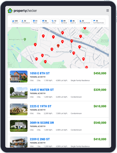
Boston, MA Ratings

  • Public Schools
  • Cost of Living
  • Health & Fitness
  • Outdoor Activities
  • Nightlife
  • Weather
  • Commute
  • Access to Bars
  • Access to Coffee Shops
  • Access to Outdoor Activities
  • Access to Parks
  • Access to Restaurants
  • Crime & Safety
  • Diversity
  • Good for Families
  • Good for Retirees
  • Good for Young Professionals
  • Housing
  • Jobs
  • Walkability
Powered by

Housing

Median Home Value:
$2,465,000
Median Rent:
$15,325
Median Real Estate Tax:
$28,023
Rent vs. Own:
21%

Crime & Safety Based on violent and property crime rates.

Jobs Based on employment rates, job and business growth, and cost of living.

Median Household Income
$151,502
National $69,021

Education Breakdown

Boston Elementary School

  • Belmont, MA
  • Academics
  • Teachers
  • Clubs & Activities
  • Sports
  • Resources & Facilities
  • Diversity
  • College Prep
  • Administration
  • Food

Boston Middle School

  • Belmont, MA
  • Academics
  • Teachers
  • Clubs & Activities
  • Sports
  • Resources & Facilities
  • Diversity
  • College Prep
  • Administration
  • Food

Boston High School

  • Belmont, MA
  • Academics
  • Teachers
  • Clubs & Activities
  • Sports
  • Resources & Facilities
  • Diversity
  • College Prep
  • Administration
  • Food

Diversity Based on ethnic and economic diversity.

Population:
27,056
Unemployment Rate:
3.8%
Powered by

Crime Stats

Violent Crime

Murder:
28
Rape:
0
Robbery:
N/A
Assault:
25

Property Crime

Burglary:
34
Larceny-theft:
54
Motor Vehicle Theft:
54
Arson:
32

Sex Offenders

James Smith
Offense: O/S RAPE AND ABUSE OF CHILD
1.5 Miles Away
More Info

Offense: O/S Rape and Abuse of Child

Name:
John Thomas Smith
Gender:
Not on File
Date of Birth:
03/25/1958
State of Birth:
Not on File
Race:
White
Height:
600
Weight:
185
Eye:
Hazel
Hair:
Brown
Category:
Sex Offender
Skin Tone:
Not on File
Scars Marks:
Scars, Scars - BURN SCARS & SKIN GRAPHS FROM KNEES TO NECK
Address:
26610 PARKER LANE
Case Type:
Not on File
Charges Filed Date:
Not on File
Arresting Agency:
Not on File
Offense Code:
Not on File
Offense Date:
Not on File
Offense Description 1:
Victim was a fourteen year old female
Offense Description 2:
Not on File
Conviction Place:
Not on File
Conviction Date:
01/12/1990
Court:
Not on File
Court Costs:
Not on File
Sentence Date:
Not on File
Probation Date:
Not on File
Disposition:
Registered
Disposition Date:
Not on File
Counts:
Not on File
Plea:
Not on File
Fines:
Not on File
Source:
SORAL
Source Name:
AL Sex Offender Registry
Source State:
AL

Offense: Aggravated Rape

Name:
John Thomas Smith
Gender:
Not on File
Date of Birth:
03/25/1958
State of Birth:
Not on File
Race:
White
Height:
600
Weight:
185
Eye:
Hazel
Hair:
Brown
Category:
Sex Offender
Skin Tone:
Not on File
Scars Marks:
Scars, Scars - BURN SCARS & SKIN GRAPHS FROM KNEES TO NECK
Address:
26610 PARKER LANE
Case Type:
Not on File
Charges Filed Date:
Not on File
Arresting Agency:
Not on File
Offense Code:
Not on File
Offense Date:
Not on File
Offense Description 1:
Victim was a fourteen year old female
Offense Description 2:
Not on File
Conviction Place:
Not on File
Conviction Date:
01/12/1990
Court:
Not on File
Court Costs:
Not on File
Sentence Date:
Not on File
Probation Date:
Not on File
Disposition:
Registered
Disposition Date:
Not on File
Counts:
Not on File
Plea:
Not on File
Fines:
Not on File
Source:
SORAL
Source Name:
AL Sex Offender Registry
Source State:
AL
James D Smith
Offense: RAPE OF A DRUGGED/INTOXICATED VICTIM
0.5 Miles Away
More Info
Name:
James D Smith
Gender:
Not on File
Date of Birth:
03/25/1958
State of Birth:
Not on File
Race:
White
Height:
600
Weight:
185
Eye:
Hazel
Hair:
Brown
Category:
Sex Offender
Skin Tone:
Not on File
Scars Marks:
Scars, Scars - BURN SCARS & SKIN GRAPHS FROM KNEES TO NECK
Address:
26610 PARKER LANE
Case Type:
Not on File
Charges Filed Date:
Not on File
Arresting Agency:
Not on File
Offense Code:
Not on File
Offense Date:
Not on File
Offense Description 1:
Victim was a fourteen year old female
Offense Description 2:
Not on File
Conviction Place:
Not on File
Conviction Date:
01/12/1990
Court:
Not on File
Court Costs:
Not on File
Sentence Date:
Not on File
Probation Date:
Not on File
Disposition:
Registered
Disposition Date:
Not on File
Counts:
Not on File
Plea:
Not on File
Fines:
Not on File
Source:
SORAL
Source Name:
AL Sex Offender Registry
Source State:
AL
James L Smith
Offense: POSSESS OR CONTROL OBSCENE MATTER DEPICTING MINOR IN SEXUAL CONDUCT
1 Mile Away
More Info
Name:
James L Smith
Gender:
Not on File
Date of Birth:
03/25/1958
State of Birth:
Not on File
Race:
White
Height:
600
Weight:
185
Eye:
Hazel
Hair:
Brown
Category:
Sex Offender
Skin Tone:
Not on File
Scars Marks:
Scars, Scars - BURN SCARS & SKIN GRAPHS FROM KNEES TO NECK
Address:
26610 PARKER LANE
Case Type:
Not on File
Charges Filed Date:
Not on File
Arresting Agency:
Not on File
Offense Code:
Not on File
Offense Date:
Not on File
Offense Description 1:
Victim was a fourteen year old female
Offense Description 2:
Not on File
Conviction Place:
Not on File
Conviction Date:
01/12/1990
Court:
Not on File
Court Costs:
Not on File
Sentence Date:
Not on File
Probation Date:
Not on File
Disposition:
Registered
Disposition Date:
Not on File
Counts:
Not on File
Plea:
Not on File
Fines:
Not on File
Source:
SORAL
Source Name:
AL Sex Offender Registry
Source State:
AL
James T Smith
Offense: 4/21/2006-SEX OFFENSE, OTHER STATE (Indecent Assault and Battery on a child under 14 (4 counts))
2 Miles Away
More Info
Name:
James T Smith
Gender:
Not on File
Date of Birth:
03/25/1958
State of Birth:
Not on File
Race:
White
Height:
600
Weight:
185
Eye:
Hazel
Hair:
Brown
Category:
Sex Offender
Skin Tone:
Not on File
Scars Marks:
Scars, Scars - BURN SCARS & SKIN GRAPHS FROM KNEES TO NECK
Address:
26610 PARKER LANE
Case Type:
Not on File
Charges Filed Date:
Not on File
Arresting Agency:
Not on File
Offense Code:
Not on File
Offense Date:
Not on File
Offense Description 1:
Victim was a fourteen year old female
Offense Description 2:
Not on File
Conviction Place:
Not on File
Conviction Date:
01/12/1990
Court:
Not on File
Court Costs:
Not on File
Sentence Date:
Not on File
Probation Date:
Not on File
Disposition:
Registered
Disposition Date:
Not on File
Counts:
Not on File
Plea:
Not on File
Fines:
Not on File
Source:
SORAL
Source Name:
AL Sex Offender Registry
Source State:
AL
Close